
2.2.4 Case study - Tītī / Cook’s petrel, Hauturu, Aotearoa New Zealand
Matt Rayner, Auckland War Memorial Museum (Tāmaki Paenga Hira)/University of Auckland
Cook’s Petrel (Pterodroma cookii) is an Aotearoa New Zealand endemic and endangered species (Vulnerable – IUCN Red List). It is restricted to breeding sites at the northern and southern extremes of its former range, with the world’s largest breeding population found on Hauturu.58
To improve the limited knowledge of the breeding habitat of this species, an island-wide survey was combined with GIS mapping techniques and logistic regression data analysis techniques to examine burrow distribution and habitat use of the species. Using a GIS and digital elevation model of Hauturu, a boundary was selected based on largely botanical information dividing the island into two strata (i.e., below and above 300m), and survey plots were generated using randomly selected coordinates. A total of 104 plots within each stratum. To minimise spatial autocorrelation in burrow counts a minimum distance rule of 100 m between sites was applied. Fieldwork for the island-wide survey was conducted during the breeding season of Cook’s Petrel. The following habitat variables were recorded within each plot:
- Canopy cover
- Canopy height
- Number of stems within the plot between 1 and 20 cm diameter at breast height (dbh)
- Number of stems within plot > 20 cm dbh
- Slope
- Aspect
Results showed that, on Hauturu, Cook’s Petrel were breeding predominantly above 300 m asl with burrows situated on steeper slopes, closer to ridge tops, and in unmodified forest habitats with low and open canopies and greater numbers of large stems compared to the available terrain and habitat. The current distribution of this population is a result of habitat selection and historical human-mediated impacts. Mature forest habitats, proximity to ridge tops, and steep slopes are key habitat requirements for this species. A large amount of suitable habitat is available for Cook’s Petrel on Hauturu and the recent removal of introduced predators was expected to result in an expansion of this population. These results provide useful information to aid in the restoration of former colony sites on other islands and the New Zealand mainland.58
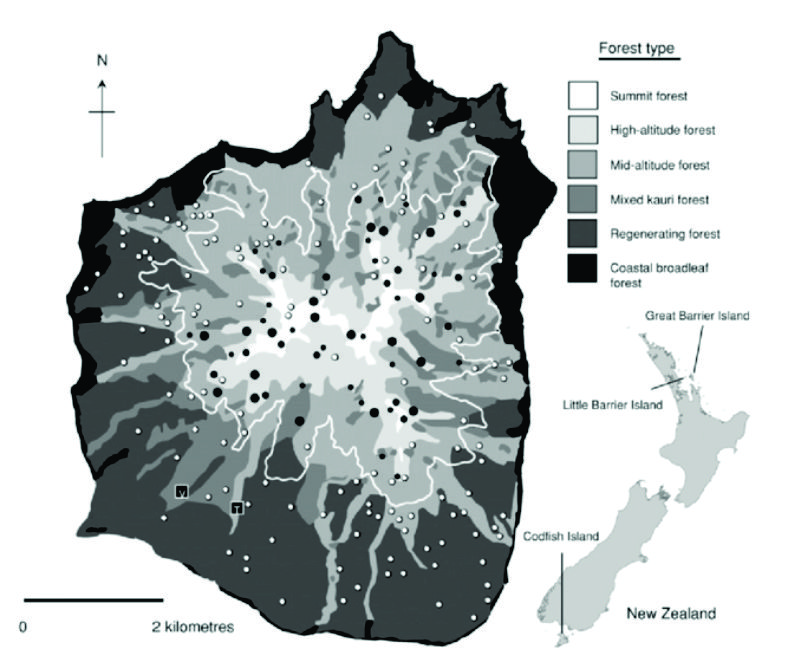
Figure 80. Map of Hauturu showing its position within New Zealand, the location of the stratified survey plots (n = 194), forest types, the 300-m altitude contour and strata boundary (white line), plots with 0, 1, 2, 3 burrows present, and the low-altitude Valley (V) and Tirikakawa (T) colonies.58