
2.2.3 Vegetation communities
A range of factors influence where seabirds breed. In the case of burrowing seabirds, these can include angle of slope, substrate, soil depth and hardness, drainage, forest type, and altitude - factors which vary from species to species. Tree nesting seabirds such as Red-footed Boobies, noddies and White Terns will favour particular tree species. Surface nesters such as Brown and Masked boobies, as well as Sooty Terns may favour open ground. Frigatebirds can be either surface-nesters or they may nest on top of shrubs. A number of tropical petrels are also surface nesters, albeit under the cover of understory vegetation. Christmas Shearwaters (Puffinus nativitatis) also nest on the ground under dense vegetation or rock outcroppings.
Understanding vegetation communities and how they can influence colony boundaries allows a shortcut approach to assessing where seabirds could be breeding in a target area. Before you start, do your homework. Use the literature to gain an understanding of what your species needs in terms of nesting vegetation. You can then use this information to help design your study as outlined below.
Method
You can incorporate an assessment of vegetation communities into your study in several ways. These include both desk- and field-based approaches.
- Desk-based approach. If you have a solid understanding of the vegetation that your species needs, you can consider undertaking a desk-based assessment to define potential colony boundaries within your study area. This can be undertaken by using Google Earth imagery (as recent as possible), aerial photographs or GIS vegetation layers to plot the vegetation communities.
- Field approaches. While carrying out desk-based modelling exercises can be extremely useful, particularly for large-scale assessments, nothing compares to going into the field – either to ground truth modelling results, or by collecting the initial data needed to create habitat models (if the breeding preferences of your species are poorly known). By undertaking an initial sample of colonies using transects, for example, the vegetation communities that influence presence-absence of colonies can be quickly revealed. Surveying using ground-search methods is demanding, so to speed the process up it can be combined with the use of a drone. In this scenario, a drone could be used to provide potential colony boundaries with only ground truthing verification required to ascertain certainty of occurrence.
The above approaches can be taken one step further by adding long-term monitoring of the vegetation and invertebrates around colonies to your seabird survey programme. By doing so, it becomes possible to monitor the extent to which the ecological functions that seabirds offer are being fulfilled which in turn reinforces the importance of seabird conservation. And as we now know from studies in places like Palmyra, seabird conservation on islands has a profound impact on the surrounding marine environment as well, so the marine environment adds another interesting element to consider (see Section 3.11 Seabird-transported nutrient monitoring).
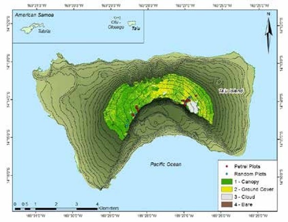
Figure 78. Map of Ta‘ū Island, American Samoa, with the summit montane habitat classified by the presence of trees (bright green) or open ground cover (yellow). Also shown are the locations of habitat classification plots (both random and petrel burrow).57
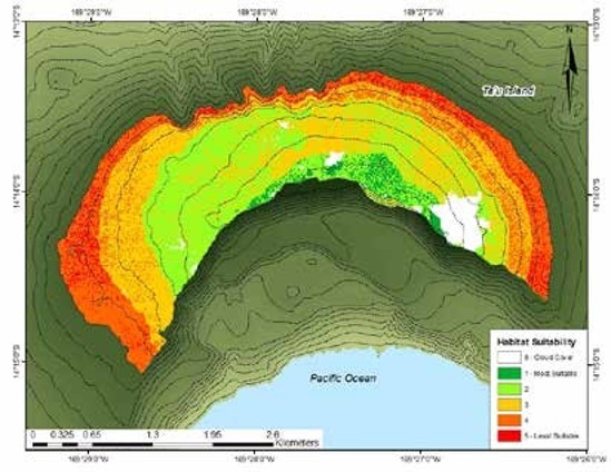
Figure 79. Map of Ta‘ū Island summit montane habitat classified by habitat suitability. The most suitable habitat (categories 1, 2) is presented in green, and the least suitable habitat (categories 4, 5) is presented in red.57